
Can we help you?
Contact us

Can we help you?
Contact us
Thank you for contacting us
Your form has been submitted successfully Our team will contact you again as soon as possible.
Whooppss...!! An error has occurred
Try sending later or write an email directly to areaempresas@ua.es

INFO
SHEET
DOWNLOAD
EXECUTIVE
ABSTRACT
CONTACT DETAILS: Research Results Transfer Office-OTRI
University of Alicante
Tel.: +34 96 590 99 59
Email: areaempresas@ua.es
http://innoua.ua.es
The UrbanMOSAICLab research group at the University of Alicante, in collaboration with the ROVIT computer science group, has developed an integrated methodology for the analysis of urban public space that operates across two complementary dimensions:
• What does the environment offer? Using 360-degree video processed with artificial intelligence models, the system automatically characterises the physical conditions of the space: architectural barriers, infrastructure, vegetation, lighting, shade, pavement condition and other indicators of urban quality.
• How does the user perceive that environment? Using eye-tracking glasses, the system captures exactly which elements attract pedestrians’ attention as they move through the space, revealing how they subjectively experience it.
For example, combining these two dimensions makes it possible to identify gaps between actual physical accessibility and perceived accessibility.
Consequently, this methodology, which has already been validated in the city of Alicante, provides both objective and perceptual evidence to support urban planning processes, accessibility assessments, the design of safe environments and the improvement of the user experience of public spaces.
The researchers are seeking companies and public/private organisations interested in collaborating to develop new projects.
Gaining an in-depth understanding of urban public space requires two types of information that traditional methods rarely combine: the objective state of the built environment and the subjective experience of those who use it. Official data sources on public space are costly to obtain, quickly become out of date and do not reflect the user’s actual perspective. Conventional audits are slow, difficult to replicate on a large scale and fail to capture the perceptual dimension.
This dual shortcoming has direct consequences: a ramp that technically complies with regulations may prove impassable in practice; a well-lit space may be perceived as unsafe; a barrier-free pavement may cause uncertainty for a caregiver pushing a wheelchair. The gap between what the environment offers and what the user perceives is precisely the blind spot of conventional urban planning.
The integrated methodology of UrbanMOSAICLab and ROVIT combines the automated capture and analysis of the physical environment with the recording of the user’s actual perception, bridging that gap and offering an urban analysis tool with great potential.
The methodology comprises two complementary technical components that can be applied either jointly or independently, depending on the project’s requirements:
COMPONENT 1: OBJECTIVE CHARACTERISATION OF THE ENVIRONMENT. 360° video + Artificial Intelligence (see Figure 1).
Systematic surveys are carried out using 360-degree video cameras across the study areas. The ROVIT IT group has developed computer vision models specifically trained for the urban environment, which process the video and automatically detect and classify: architectural barriers, vehicles, pedestrian crossings, vegetation, lighting and shade, pavement condition, signage, street furniture and other quality indicators. Each element is georeferenced, generating layers that can be integrated into a GIS and quantitative indicators that are comparable over time.
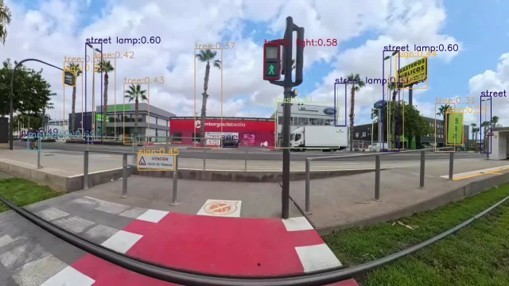
Figure 1: Still from the 360° video
COMPONENT 2: CAPTURING THE USER’S PERCEPTION. Eye-Tracking Glasses + Artificial Intelligence (see Figure 2)
The wearable eye-tracking glasses are worn whilst the participant undertakes a real-world walk through the urban environment. They simultaneously record: the exact direction of gaze at any given moment, the full field of view captured on first-person video, and attention metrics (fixations, attention time per element). UrbanMOSAICLab’s proprietary protocol combines this data with on-the-go interviews (think-aloud), in which the participant verbalises what they observe and experience. The data is georeferenced and integrated with that from Component 1 to produce comprehensive spatial analyses.
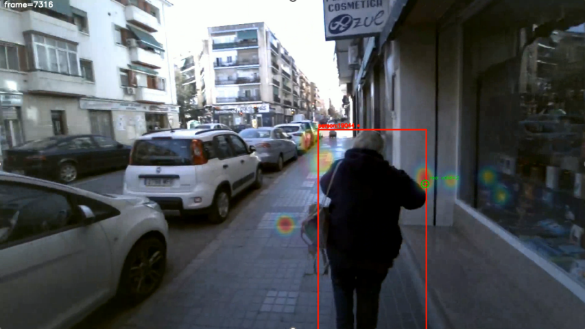
Figure 2: Capturing the view through the eye-tracking glasses
The integration of these two components provides a dual perspective on the same space: the objective conditions it presents, and how these are perceived and assessed by users. By adjusting the parameters of analysis — lighting, viewing angles, the presence of people, and the boundaries of spaces — the methodology can be tailored to investigate a wide range of aspects of the urban experience: physical and perceived accessibility, perceived safety, thermal and visual comfort, commercial appeal, or the overall quality of public space.
MAIN ADVANTAGES
• A comprehensive view of urban space: objective conditions (Component 1) and user experience (Component 2), two dimensions that conventional methods rarely combine.
• It enables the identification of the gap between actual physical accessibility/safety and perceived accessibility/safety: the space that ‘is’ versus the space that ‘feels’ like.
• Many other physical parameters of the environment (lighting, infrastructure, vegetation, shade, pavement condition, mobility, etc.) are analysed in conjunction with users’ visual attention.
• The georeferenced data obtained generates layers that can be integrated into GIS and quantitative indicators that are comparable over time.
• Significant reduction in time and cost compared to conventional audits.
• Applicable to any user group; particularly useful for vulnerable groups (who are often overlooked in urban analyses), such as older people, caregivers or people with reduced mobility.
• Flexible: the two components can be applied together or independently.
• Methodology fully adaptable to the analysis parameters of each project or organisation.
INNOVATIVE ASPECTS
• The first methodology to systematically combine objective analysis of the urban environment using AI with the capture of users’ actual visual perceptions via eye-tracking, alongside live feedback.
• AI models (ROVIT) specifically trained for urban public spaces, with simultaneous detection of multiple variables.
• An open methodological platform: by adjusting the analysis parameters of Component 1 (which elements of the environment are detected and measured) and the participant profiles of Component 2 (which users undertake the walk), the methodology can be adapted to investigate virtually any aspect of the relationship between the built environment and human experience: environmental comfort, commercial appeal, pedestrian stress, urban orientation and legibility, perceptions of neglect or maintenance, and other aspects yet to be explored.
The methodology is currently being applied in two research projects in the city of Alicante:
• INCLUSIVEnodes Project: ‘Perceived accessibility in urban transport hub environments from the perspective of unpaid care work: Diagnosis and urban regeneration strategies for an inclusive city’ (PID2024-157422OA-I00) — Ministry of Science and Innovation (2025–2028).
Comprehensive analysis of urban accessibility in the areas surrounding TRAM stops (Garbinet, Mercado, Pintor Gastón Castelló). This combines 360° video footage processed using AI to characterise the physical conditions of the environment, with walks undertaken by real caregivers wearing glasses that record their perception and direct experience of the space.
• CENID 2025 Project “Analysis of perceived urban safety in the neighbourhoods of Alicante”. University of Alicante / ROVIT group
It applies the methodology of 360° video and artificial intelligence to detect and quantify the physical factors in the environment that influence perceptions of safety — lighting, visibility, vegetation, signs of deterioration, presence of activity — in three neighbourhoods of Alicante with contrasting urban profiles: Garbinet, Virgen del Remedio and Mercado. The project includes the collaborative web platform ALISAFE, featuring publicly accessible, georeferenced safety indicators.
Both projects validate the methodology in real-world and diverse contexts — accessibility and mobility of care, and perceptions of safety — demonstrating its ability to adapt to different research questions concerning the urban environment. The technology is available for use in projects with businesses, organisations and public institutions.
The methodology is directly applicable in all areas where it is necessary to understand both the physical conditions of the urban environment and the experience of its users:
• Physical and perceived accessibility
Comprehensive accessibility assessment: identification of actual physical barriers (Comp. 1) and how these are perceived by different types of users (Comp. 2). Particularly useful for evaluating public transport environments, pedestrian routes and everyday spaces for people with reduced mobility or caregivers.
• Perception of urban safety
By combining physical parameters of the environment — lighting, visibility, detected activity, scale of spaces — with users’ actual visual attention, the methodology enables research into which factors of the built environment contribute to a sense of safety or insecurity. Applicable to situational prevention policies, safe urban design and the assessment of problematic public spaces.
• Walkability and the quality of public space
Assessment of pedestrian-friendliness by combining objective conditions (pavement condition, shade, vegetation, continuity of pavements) with the subjective experience of the route (which elements attract attention, what opinions are expressed). Applicable to sustainable urban mobility plans, urban regeneration and walkability assessments.
• Research into other aspects of the built environment
The methodology acts as a configurable research platform: by modifying the parameters analysed by the AI model in Component 1 — for example, incorporating the detection of artificial lighting, vegetation cover, density of active façades or the presence of other users — and by selecting the appropriate participant profiles in Component 2, it is possible to direct the analyses towards a wide range of research questions: environmental and thermal comfort, legibility and spatial orientation, perceptions of neglect or urban maintenance, pedestrian stress, or any other dimension of the experience of the built environment that requires linking objective physical conditions with the user’s perceptual response.
The group is seeking companies or public/private organisations interested in collaborating to apply this methodology to public spaces: research contracts, the provision of analytical services, licences to use the methodology, methodological consultancy and collaboration on R&D projects.
Examples of areas of application:
• Public administrations (local, district, regional): accessibility audits, mobility plans, evaluation of urban policies.
• Public transport operators: comprehensive assessment of the surroundings of stops, stations and transport hubs.
• Consultancy firms specialising in urban planning, architecture and landscape architecture.
• Urban and commercial marketing: analysis of visual attention on building façades, shop windows and signage.
• Research into urban health, risk perception, pedestrian behaviour and care mobility.
• Insurance, valuation and risk assessment in urban environments.
The integrated methodology is protected as part of the know-how of the UrbanMOSAICLab and ROVIT research groups at the University of Alicante. The artificial intelligence models have been developed and registered by the ROVIT group’s IT team. The proprietary methodological protocol is the result of the INCLUSIVEnodes project (PID2024-157422OA-I00), funded by the Ministry of Science and Innovation.
Social Studies
Regional Planning


Carretera San Vicente del Raspeig s/n - 03690 San Vicente del Raspeig - Alicante
Tel.: (+34) 965 90 9959