
Can we help you?
Contact us

Can we help you?
Contact us
Thank you for contacting us
Your form has been submitted successfully Our team will contact you again as soon as possible.
Whooppss...!! An error has occurred
Try sending later or write an email directly to areaempresas@ua.es

INFO
SHEET
DOWNLOAD
EXECUTIVE
ABSTRACT
CONTACT DETAILS: Research Results Transfer Office-OTRI
University of Alicante
Tel.: +34 96 590 99 59
Email: areaempresas@ua.es
http://innoua.ua.es
A Spanish research group has developed a multimedia location system for routes on foot. It includes the information presented through many ways: text, images, videos, 3D outlooks, audio... and it is mainly addressed for reduced surroundings as a city, a university centre or a museum. It can be accessed from many mobile devices, through the Web or by means of external store devices. The group looks for companies or entities interested in adapting the technology to their specific applications.
A Spanish research group has developed a multimedia location system for routes on foot (pedestrian navigation system (PNS)).
Pedestrians are some times in unknown urban environments, buildings or places. In these cases, they need a guidance to arrive to a place. The pedestrian navigation system (PNS) helps the user to know where he or she is, what to do or see, etc.
The developed tool includes, unlike most localization-based systems, information presented through many ways: text, images, videos, 3D outlooks, audio... and is mainly addressed to take into account the pedestrian navigation in reduced surroundings as a city, a university centre, a museum...
The pedestrian navigation systems generated by the tool, can be accessed from many mobile devices (phones, PDAs, TabletPC, hybrid devices PDA/TabletPC + telephone), through web from a personal computer or by external store devices (CDs, DVDs...).
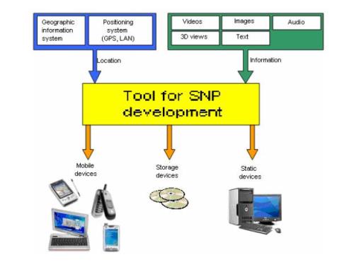
The tool allows carrying out pedestrian navigation systems with different requests, depending on the kind of information to present or to use, and depending on the kind of presentation (See figure). We have two types of information:
· Information about the user localization that will be obtained from geographic information systems and from the interpretation of the user position through GPS, WLAN...
· Graphic information about the surroundings where the user is, as well as, ifnecessary, about the route to follow to a certain destination. This visual information will be given by images, 3D outlooks, videos, textual information presented on the visual one, audio...
On the other hand, the pedestrian navigation system, with more or less interaction level can be accessed from a mobile device, Internet or from static storage devices.
Therefore, the development of this tool has different parts:
· The interface with the used localization system: it is provided a way to incorporate the information of a positioning system that can vary depending on its internal or external use (GPS, WLAN...).
· Friendly surroundings for the presentation design are provided. Notice that, probably, the design done, for example, for a personal computer will not be useful for a PDA or mobile phone, due to the smaller size of the screens of these mobile devices. Therefore, the tool must give flexible solutions that allow providing moreor less information depending on the device, or to do a simplified presentation of it.
· The presentation of the route to follow can be showed in different ways: a route drawn on a map, a series of photographs, 3D outlooks and videos. For the last case, in order to have a more visual way of showing the route to follow, it could be possible to take images or videos of the different ways that the pedestrians can follow. Through a lattice representation of the possible routes to follow, it must be allowed the allocation of each one of these graphic elements to the lattice edges. So that the route to follow will be shaped by a series of edges from origin to destiny.
· Copy-out of the navigation system to access from a specific device.
INNOVATIVE ASPECTS
The locating-based applications are still in an initial development phase. Until now, they are limited to navigation and locating of vehicles. For this reason, this tool can facilitate the pedestrian navigation systems design. On the other hand, the incorporation of visual information is also in early stages. The application of 3D outlooks and videos to virtual visits is beginning. For that reason, the locating information with this incorporation is completely novel. All these make the developed tool of high exploitation expectative.
MAIN ADVANTAGES
The tool for PNS development is novel because there are no applications on the market that allow the design of pedestrian navigation systems with friendly and flexible surroundings.
The most outstanding advantages are:
- It is possible to introduce the desired information in the system
- The presentation mode can be personalized in a quick way
- A copy-out to different platforms (mobile or static) is possible
The current developed systems are done directly, that is to say, without using any tool.
For that reason, this tool reduce costs because the effort must not be done in the pedestrian navigation systems programming, but in studying what information is presented and how, depending on the access devices, taking into account the reduced screen size and the communication speed.
Consequently, the design of PNS using this tool will be very fast and will have high flexibility. In this way, implantations of the navigation systems in cities, university centres, museums could be done in a quick way. What is more, this implantation can be progressive, because once the visual information is incorporated; it can be for example, on first place, designed the virtual visit to the place, to lately do the design for mobile devices.
The pedestrian navigation systems developed with the tool can be designed for several and different ambits:
· In a university or research centre, through the possibility of informing about the route to follow to arrive to a building, office...
· In the tourist sector, the possibility of offering tourist routes to the visitors that can be done by foot, with information about localization, way to follow, details about interesting places...
· In a museum, to guide the user’s visit, showing videos and audio that present additional information, for example, paintings explanations, use of prehistoric tools...
Technical Co-operation
· Type of partner sought: the group looks for companies or entities interested in adapting the technology to their specific applications.
· Specific area of activity of the partner: companies or entities related to navigation systems or to tourist or guidance activities.
· Task to be performed: the companies that are interested in this particular area of activity should be willing to adapt the technology to their specific needs as well as to finish the parts of the technology that need a further development.
The research team of this project belongs to the research group of “Industrial Computing and Computer Networks” of the Computer Technology and Computing Sciences Department from the University of Alicante. The research fields of the group are artificial intelligence, control, vision and networks. They have carried out several contributions that are applicable in industrial contexts (artificial vision systems, mobile robots control, design and computer-assisted manufacture) and in images and systems modelling with biomedical origin (diagnostic and classification).
The team is formed up by four doctors and three computer engineers that are now finishing their doctorate thesis in issues related to the image treatment and computer vision. The team members have a high experience in managing and participation in research projects with funding both public and private.
The former projects and the current ones in which the researchers have participated have been financed by public organizations as the Ministry of Education and Science, the Ministry of Science and Technology or the Presidency and the Culture, Education and Sport Department of the Valencian Government. At present, the group has four projects: “Vision by outer intelligent robot for autonomous mobile systems” financed by the Ministry of Science and Technology, “Computing Palaeontology: data management and computing applications development in palaeontology”, “Architecture model specialized in computing geometry processing” and “Quality control of glossy and reflective surfaces by artificial vision” financed by the Culture, Education and Sport Department of the Valencian Government.
Computer Science, Language and Communication


Carretera San Vicente del Raspeig s/n - 03690 San Vicente del Raspeig - Alicante
Tel.: (+34) 965 90 9959